Urban areas are notorious for presenting unique obstacles to high-precision positioning systems. Traditional Global Navigation Satellite Systems (GNSS), especially Real-Time Kinematic (RTK) ones, face severe challenges due to myriad factors such as tall buildings, antennas, and other urban structures that frequently obstruct satellite signals. As a result, the accuracy and reliability of these systems suffer considerably, making conventional methods insufficient for modern precision demands.
Despite previous endeavors to mitigate these issues through alternative technologies like Wi-Fi and Bluetooth, they often lack the necessary robustness. However, advancements in 5G technology offer a more promising avenue for enhancing positioning systems. With its increased speed and capacity to support high data transmission rates in densely populated areas, 5G could provide significant improvements in urban navigation accuracy.
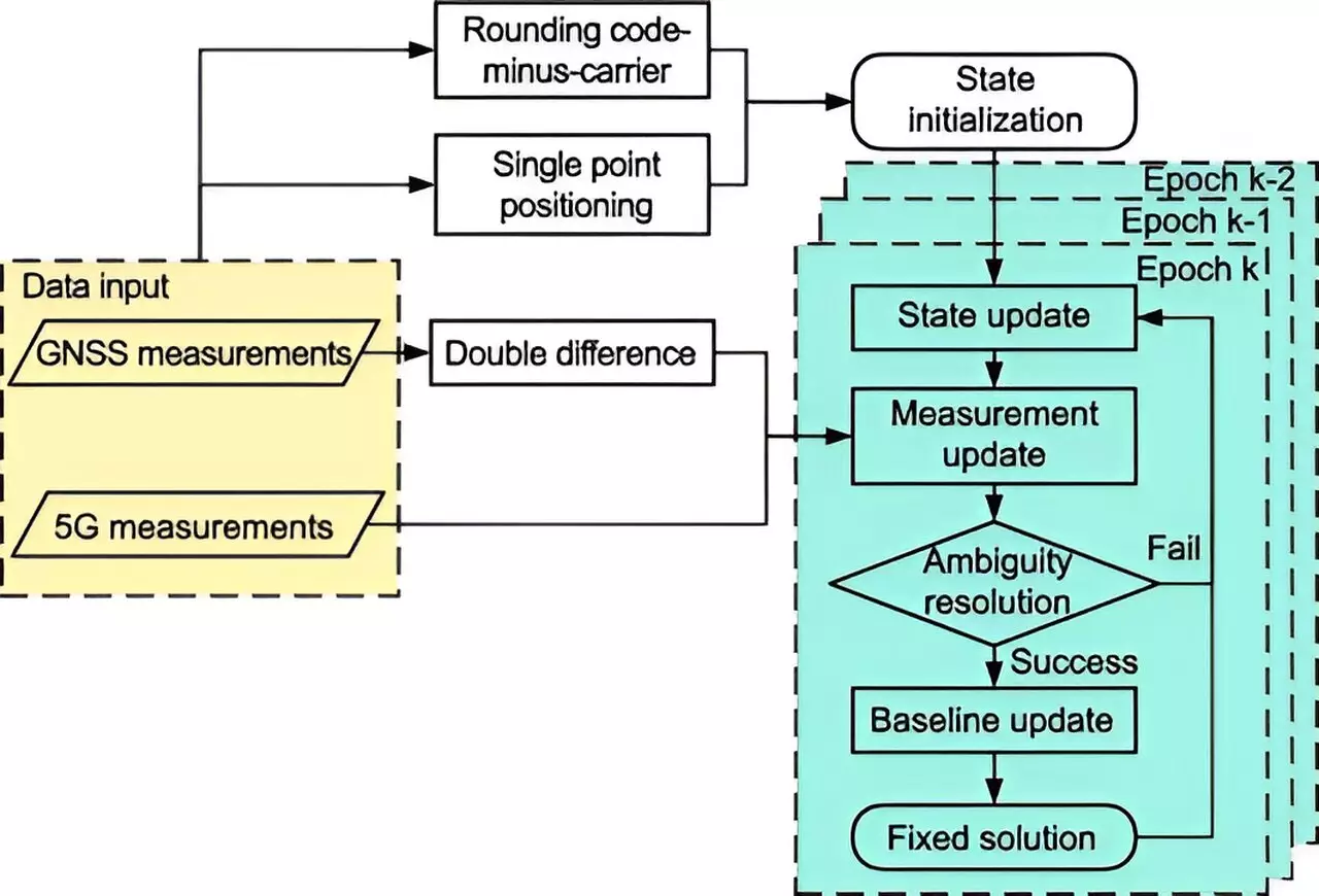
A groundbreaking research study conducted by Tsinghua University has led to the development of an advanced 5G-assisted BeiDou Navigation Satellite System (BDS) RTK positioning system, as highlighted in a recent publication. By integrating 5G observations with traditional satellite data and employing cutting-edge statistical techniques such as the extended Kalman filter and sophisticated ambiguity resolution methods, this new system demonstrates remarkable improvements in positioning accuracy.
The significant findings from this study showcase a substantial reduction in spatial errors, with full ambiguity resolution (FAR) mode achieving a remarkable 48% decrease in errors and partial ambiguity resolution (PAR) mode achieving an 18.8% reduction. Moreover, the system’s fixing rates improved from 11.11% in FAR mode to 13.93%, while the PAR mode saw an increase from 32.58% to 44.43%. These gains underline the effectiveness of 5G technology in addressing the inherent signal disruptions faced in urban setups.
The potential impact of integrating 5G with BDS RTK positioning extends beyond mere academic interest; it presents practical applications across a variety of fields. With enhanced positioning capabilities, critical sectors such as autonomous vehicles, public safety, and smart city frameworks can greatly benefit. The integration lays the groundwork for reliable urban navigation solutions, particularly in scenarios where traditional approaches struggle to deliver accurate results.
Dr. Tengfei Wang from Tsinghua University emphasized the transformative nature of this technology, stating that it significantly enhances signal quality and satellite visibility in urban environments. This innovation heralds an era of new possibilities for navigating the challenges posed by complex city landscapes.
As 5G infrastructure continues to expand globally, the 5G-assisted BDS RTK positioning system offers a scalable and adaptive solution to improve location-based services. Future research is expected to further refine system performance in diverse real-world environments, focusing on maximizing accuracy and reliability. The findings may lead to widespread application, enabling cities to leverage advanced positioning technologies to meet the increasing demands of modern urban life. As researchers delve deeper into this integration, the prospects for achieving unparalleled urban positioning accuracy are indeed promising.

