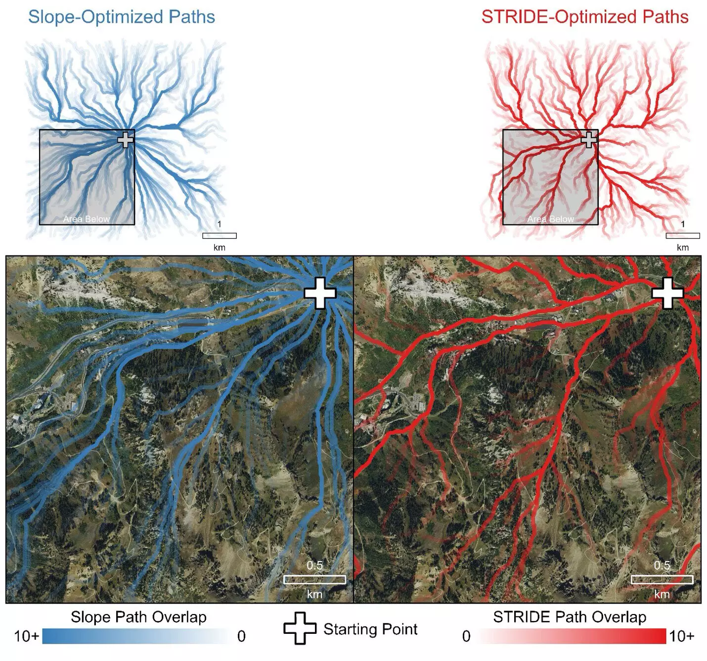
Natural disasters, such as wildfires, highlight the urgent need for efficient and safe evacuation strategies. With unpredictable fire behavior, firefighters often find themselves in life-threatening situations that require not only quick decision-making but also accurate assessments of their escape routes. The introduction of a new model, STRIDE (Simulating Travel Rates in Diverse Environments), offers a sophisticated approach to estimating evacuation times that considers various terrain factors beyond mere slope, potentially saving lives by enhancing firefighter mobility.
Every second counts when firefighters are forced to flee a wildfire that breaches safety lines. Traditionally, they have relied on experience and intuition to navigate escape routes, facing significant challenges due to the diverse and rugged nature of the terrain. Existing models for predicting travel times largely emphasized slope steepness but overlooked crucial aspects such as vegetation density and ground roughness. This gap in the modeling process often led to inaccurate estimates, potentially resulting in disastrous consequences during critical situations. The necessity for a more comprehensive model is evident not only for firefighters but for a range of professionals, from disaster responders to outdoor enthusiasts.
Developed by researchers from the University of Utah, STRIDE is groundbreaking in that it integrates multiple terrain characteristics to enhance predictions of mobility in various environments. Unlike conventional models, STRIDE takes into account not just the incline of the ground but also the composition of the landscape, such as vegetative cover and ground texture. This multi-dimensional approach enables a more realistic assessment of the challenges faced by individuals traversing different types of terrain.
The STRIDE model utilizes advanced data from Light Detection and Ranging (LiDAR), which provides exceptionally detailed maps of the landscape by analyzing the laser pulses that bounce off various ground elements. The incorporation of this technology allows the model to accurately identify paths of least resistance — a critical factor for those who need to find the quickest and safest escape routes during emergencies.
The efficacy of STRIDE was validated through field trials that entailed measuring travel times taken by volunteers navigating 100-meter transects across varied landscapes. Conducted over several years, these trials compared STRIDE’s predictions against conventional slope-only models. The results were stark: STRIDE effectively mimicked intuitive travel choices, favoring established roads and trails while avoiding more challenging terrain. This accuracy in route selection is vital; as highlighted by tragic past incidents where firefighters were caught by wildfires, having a better framework for understanding mobility could very well be life-saving.
While the initial focus of STRIDE was on improving firefighter safety, its potential applications extend across several fields. From emergency medical services to archaeological site exploration, the versatility of this model allows varied professions to plan safer and more efficient navigation through complex environments. For instance, in urban settings, understanding pedestrian mobility using STRIDE can inform public safety protocols during disasters, ensuring quicker response times and efficient evacuation strategies.
Moreover, the STRIDE model is publicly accessible, enabling anyone engaged in planning or recreation to utilize its sophisticated capabilities for route estimation. By openly sharing their methodology and findings, the researchers place powerful tools into the hands of practitioners across disciplines, emphasizing collaboration and innovation in enhancing public safety.
The development of STRIDE represents a significant advancement in our comprehension of travel dynamics in hazardous landscapes. Integrating critical variables into escape route modeling not only provides accurate predictions but also unlocks deeper insights into human mobility patterns under duress. The approach taken by the researchers illustrates that effective emergency planning is not merely a theoretical exercise, but rather, it holds substantial real-world implications.
As emergency response protocols continue to evolve, models like STRIDE will play a crucial role in informing strategy and decision-making across various contexts. By accurately mapping the intricate interactions between terrain and vegetation, STRIDE lays the groundwork for a safer future in wildland firefighting and beyond, potentially setting new standards for operational practices in disaster management.

