
Air quality has rapidly deteriorated due to urbanization and industrialization, leading to detrimental health effects and environmental degradation. At the forefront of tackling this crisis is nitrogen dioxide (NO2), a pollutant primarily released from combustion processes in vehicles and power plants. This article outlines a groundbreaking study showcasing the revolutionary potential of modern satellite technology in detecting and mapping nitrogen dioxide emissions effectively, marking a pivotal shift in air quality monitoring.
Traditionally, satellite imagery has been a vital tool for assessing various environmental parameters, including land use and natural resource management. However, a significant limitation has been its inability to deliver the spatial resolution necessary to accurately identify pollution sources like power plants. Recent advancements, particularly the utilization of images from Copernicus Sentinel-2 satellites, have opened new vistas for monitoring air pollution with remarkable precision.
While past algorithms yielded only coarse resolutions, the innovative application of Sentinel-2 imagery now demonstrates an ability to observe nitrogen dioxide plumes from specific power plants. Unlike its predecessor, Sentinel-5P, which largely focused on nitrogen dioxide mapping, Sentinel-2 was initially designed for land monitoring. Its dual capability allows it to capture high-resolution images, facilitating the detection of atmospheric pollutants.
One of the study’s remarkable aspects is its use of blue and ultrablue spectral bands, enabling researchers to glean insights into NO2 emissions even in complex environments. This unexpected utility suggests a significant leap in our understanding of how to harness satellite technology to address air quality challenges, especially in densely populated urban center areas.
Case Studies from Around the Globe
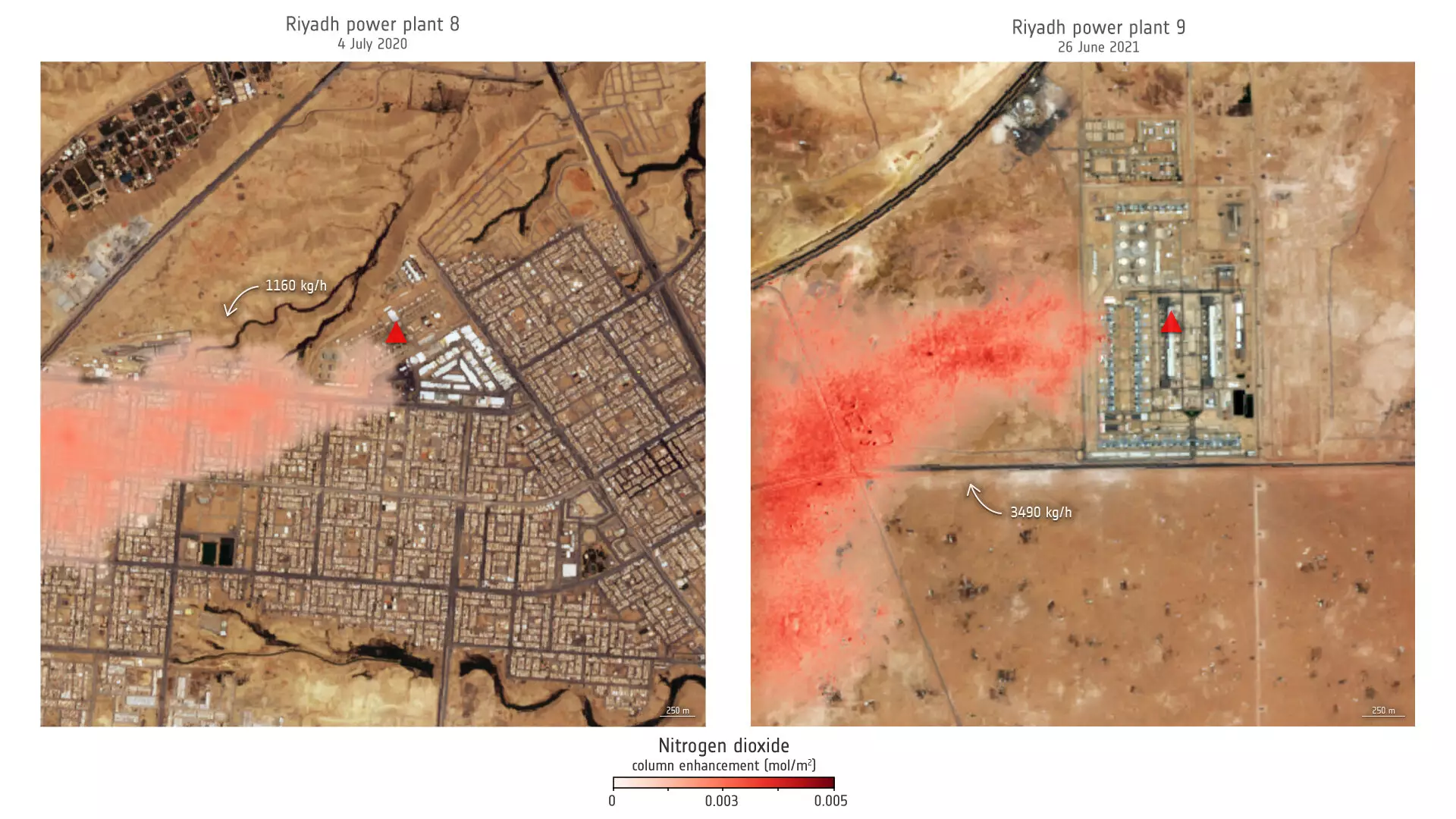
The study employed precise imagery to assess nitrogen dioxide emissions from power plants in Saudi Arabia and the United States. In Riyadh, for instance, data analysis covering a decade revealed annual peaks corresponding to increased air conditioning use in summer months. Such granular insights can help policymakers enact targeted interventions that address seasonal variations in emissions.
The ability to study emission trends over prolonged periods further amplifies the relevance of this research. By leveraging datasets from both Sentinel-2 and U.S. Landsat satellites, researchers can paint a comprehensive picture of pollution trajectories and target interventions effectively.
In Wyoming, similar analyses revealed emission rates that could inform local environmental regulations or utility company practices. This extensive capability can drive progress toward cleaner energy solutions and ultimately a healthier atmosphere.
The implications of this study extend far beyond merely pinpointing pollution hotspots; they offer a larger strategic framework for air quality management. With the combination of high-resolution imagery and actionable data, environmental agencies gain a powerful tool to identify not only when and where emissions are coming from but also the volume and composition of those emissions.
As Daniel Varon, lead researcher for the project, noted, the ability to detect nitrogen dioxide emissions with fine spatial resolution is particularly beneficial in urban environments. Being able to identify sources amidst densely packed sectors will allow for more effective regulatory strategies, targeting companies and practices most responsible for air pollution.
Furthermore, this technology has the potential to offer ongoing monitoring capabilities, allowing for real-time assessments to track the success of implemented policies and technologies. Whether through regulatory frameworks or public awareness campaigns, the insights derived from satellite data can help shift public behavior and corporate practices toward more sustainable options.
Despite the promising developments, the research does highlight intrinsic challenges in utilizing satellite imagery for pollution monitoring. The technology often performs optimally over uniform surfaces and may struggle in regions characterized by rugged terrain or complex urban layouts. However, such limitations should not overshadow the breakthroughs achieved; rather, they present an opportunity for future innovation and continuous improvement.
The successful deployment of these satellites not only underlines an important step in monitoring air quality but also suggests a broader acceptance of satellite technology as a standard for environmental assessment and management. The upcoming launch of Sentinel-2C in 2024 promises to further enhance these capabilities, giving hope for even more detailed and widespread monitoring.
The integration of satellite technology into air quality assessment represents a transformative moment in combating atmospheric pollution. By unveiling innovative pathways to detect pollution at an unprecedented level of accuracy, we move closer to proactive global efforts for cleaner air and a healthier planet.