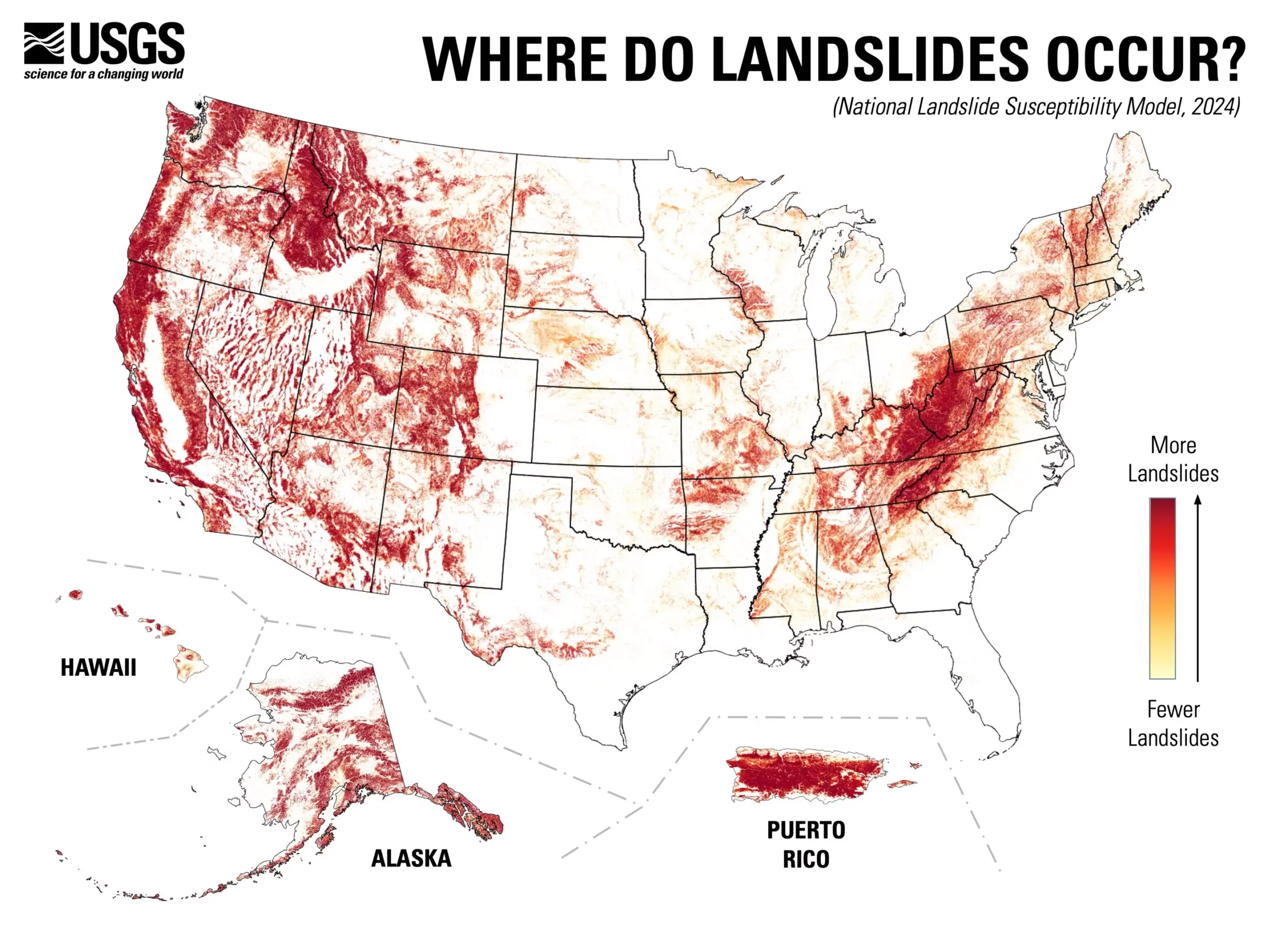
The U.S. Geological Survey (USGS) has unveiled an extensive nationwide landslide susceptibility map that reveals a staggering statistic: nearly 44% of the United States is at risk for landslide activity. This new assessment provides an invaluable tool for understanding which areas are more prone to these geologic hazards. With an intricate, county-by-county breakdown, the map highlights regions where landslide risks are significant while also identifying areas of minimal concern. This duality equips urban planners, engineers, and emergency responders with critical data to inform risk mitigation strategies and proactive planning for land use.
The significance of this map extends beyond just data presentation; it represents a pivotal shift in landslide risk assessment across the nation. For years, detailed mapping was limited primarily to specific regions with known high risks, leaving many other vulnerable zones overlooked. By broadening the scope of assessment, this map illuminates the potential for landslides in areas that previously lacked a thorough understanding of their susceptibility. According to Ben Mirus, a research geologist with the USGS, this development is crucial for enhancing national preparedness against geologic hazards.
Creating such an exhaustive and detailed map was no small feat. Mirus and his team utilized an impressive inventory that catalogues nearly one million previous landslides across the United States. Coupled with high-resolution national elevation data from the USGS 3D Elevation Program, they employed sophisticated computing techniques to develop a robust susceptibility model. This rigorous methodology resulted in a map that not only showcases landslide-prone areas but also sets a higher standard for accuracy compared to existing continental and global landslide assessments.
This newfound information is not merely academic; it directly influences practical applications in risk reduction and emergency preparedness. By visually representing areas that are at higher danger levels, the map aids in the prioritization of resources, ensuring that planners and engineers can strategically focus their efforts where they are needed most. Additionally, this tool identifies zones that require further examination and additional mapping, paving the way for informed decisions that could save lives and property.
The launch of the USGS landslide susceptibility map marks a significant advancement in understanding the geological hazards that threaten a large portion of the U.S. population. With nearly half the country potentially susceptible to landslides, the implications for land management and risk assessment are profound. As this critical data becomes publicly accessible, it encourages individuals and communities to embrace a culture of preparedness. By understanding where hazards lie, efforts can be made to mitigate risks effectively, ultimately contributing to a more resilient and hazard-ready nation.

